
I'm writing this at 5AM on Day 4. I'll try to record as much as I can remember. The trip hasn't been entirely eventful so far:
We landed in Hong Kong almost an hour early, which was great because I had had my fill of sitting in coach for the time being. The views as we flew in were spectacular, with all of the little islands with steep, abrupt-rising hills and mountains and skyscrapers crammed in wherever possible.
The airport looked like any other airport I've seen. Immigration was easy and uneventful. I met up with my driver on the other side of customs.
When we stepped outside together I got my first taste of the heat and humidity. The air was much denser and wetter than what I can ever remember feeling, but I'm sure it was skewed by the fact that a) I came from dry southern California, and b) I had just spent over 12 hours on a plane with recycled air.
The driver shuttled me toward the Chinese border in some kind of Toyota van that they don't sell in the states. He was friendly enough. I think he said his name was Willie. We talked about Shenzhen and how he was from Hong Kong. Willie looked quite young.
The route from the airport to the border snakes around a few different islands, with great views of the lush Hong Kong countryside. We arrived at the border, where I had to get out of the van, go through an immigration line, and meet back up with the van on the other side of the building, all the while Willie taking my things through customs. It was a 15 minute, uneventful affair.
On the other side of the border, we were immediately immersed in urban Shenzhen. We drove through the Futian district, toward Nanshan, where my hotel is. The streets were nice and clean and everywhere was packed with cars, bicycles, and pedestrians.
Willie dropped me off here at the Crown Plaza. I had no trouble checking in. I went up to the room, showered, and looked around for something to eat. The only things in the minibar were candy bars I wasn't interested in, and a bag of "mixed snack" that had some prawn sauce crackers in it. Instead, I got dressed and went across the street to the 7-11, where I found some cucumber flavored Lay's potato chips. I got those and a Carlsberg beer and took them back to my room as a little dinner. The chips were very strange tasting. I don't think I'll buy them again.
The little trip to 7-11 was my first taste of Shenzhen. I don't know why, but I had imagined I'd see a bit more English on signs to help me through, but there wasn't any. The streets were packed with people and I had no idea what shops were what. At 7-11 the girl behind the counter gave me a strange scowl when she discovered I didn't speak the language.
I went to bed at 10PM and slept like a rock. I thought my ploy to stay up all night might have helped me avoid jet lag, but here I am typing a post I started at 4:30AM. I'm sure my body will adjust to the time zone just in time for me to go back to California, in the less forgiving direction (losing time rather than gaining it).
Thursday, August 12, 2010
China Visit - Day 1 - Tuesday, August 10
Here are the notes I took from my first day of travels, typed on the iPad on my flight from San Francisco to Hong Kong:
The night before my flight, I stayed up all night doing chores, packing, playing games, and trying to avoid jet lag.
I left with Kimberly for the Flyaway at 5:30AM. I was at the airport and through security by a little after 7, with over 3 hours till boarding.
Ate a Clif bar for breakfast and joined the a conference call. I was even able to see the presentation with my iPad via the WebEx app. I got in a small nap before boarding.
I saw the San Fernando Valley from the plane after take-off. L.A. had a thick layer of fog/smog, and there was a legit fluffy white marine layer colliding with the basin way out into the ocean. As usual, the San Gabriels peaked up above it all, crystal clear.
It was otherwise an uneventful flight to SFO. The plane made its way between the marine layer off the coast and the dirty smog of the central valley. I did see the Romero Canyon trail snaking up to El Camino Cielo on the ridge of the Santa Ynez mountains behind Carpinteria, which we hiked once. I slept most of the rest of the short flight after that.
I walked a long way from the domestic to international terminal at SFO, but still had about an hour before boarding the plane bound for HK. The only food choice next to my gate was a little French/Italian cafe. I had a caprese sandwich, which I salvaged into something relatively tasty with some brown mustard and black pepper, and a conspicuously good no-name Italian-sounding pale ale. I found out when I was leaving that it was actually Sierra Nevada branded especially for their restaurant.
I'm on a 747 for the big flight. I slept for a bit after take-off, unfortunately missing a snack and drink of some sort, but before I could ask for something anyway they started serving lunch, which was lettuce with some decent sesame Ginger dressing, a roll, and very lackluster pasta with red sauce and too much cheese.
Iron Man 2 had just started whe I woke up, so I watched the rest of that. Other than that, I:
-listened to several albums
-read my book and magazines
-read an article that was still open on wikipedia on the iPad about the Frontier strip
-ate a couple granola bars
-did some training slides on the laptop
-watched a couple episodes of the anime Trigun on the laptop
-watched the movie Date Night with Steve Carrell and Tina Fey, also presented on the plane
-played games on the iPad
-watched the only movie on the iPad, the short part 1 of Wes Anderson's the Darjeeling Limited, called Hotel Chalier
-took a bunch of notes for my meetings in the coming week
All that and there are still four hours to go!
The laptop is nearly dead but the iPad still has 53% charge. I'll have to try to port some of my backed up DVDs to the iPad while I'm here so I have more entertainment options on the long trip back. Now they're playing some Miley Cyrus movie that I'm unlikely to give a chance.
Now I'm listening to Headlights, an album purchased at their show with David Bazan in Santa Barbara. I suddenly miss Kimberly and California quite acutely. We're almost done flying by Japan, though not close enough to spot any land, as far as I've seen. I dozed off when we flew over Tokyo.
Bleck. I was served rice and veggies, but the veggies are in some kind of sauce and there's no way to tell if it's animal based. Doesn't taste right to me. I'll have to plan my travel back a bit better than I did on the way out. I have a bunch of protein bars, but eating so many is doing a number on my digestive system. One can at least find some nuts and pretzels that are safe, I'm sure.
Saturday, May 1, 2010
Back to the Simi Hills
When Kimberly has class on Saturday mornings, it's a good opportunity for me to get up early and get in some outdoor exercise. Today was no exception. I biked with her to CSUN and then kept going to the western edge of the valley.
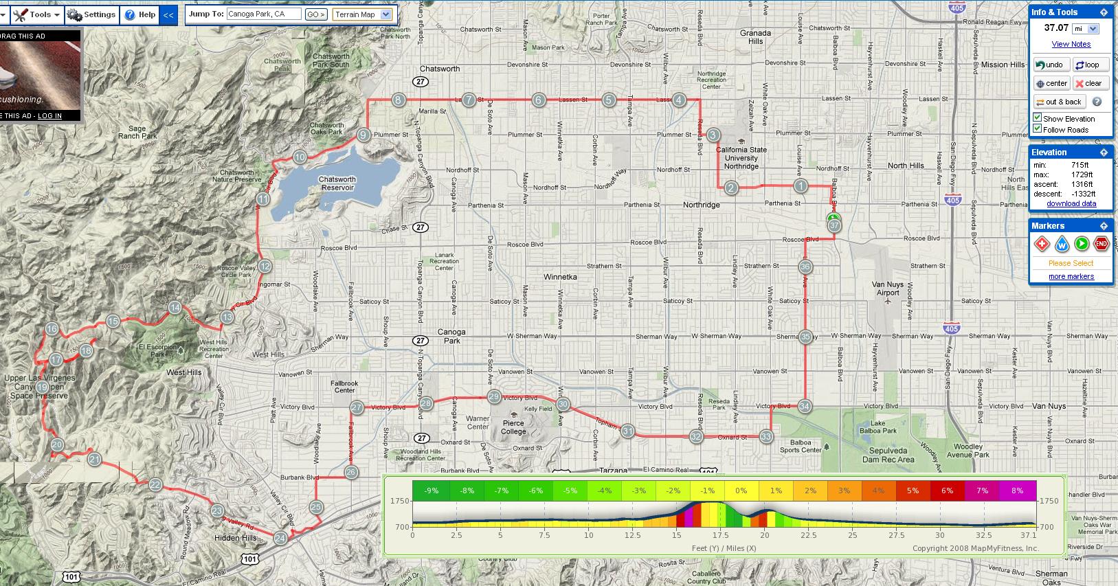
I circumnavigated the back of what looks like a sizable lake on the map (Chatsworth Reservoir), but was actually an almost completely dry flood basin. I saw a family of bunnies.
Past the reservoir I left the valley on a road called Bell Canyon, which climbed up to a gated community. There were several miles of nice homes crawling up every available side of the canyon walls. This section of the trip was the toughest. Over the four miles up Bell Canyon the road rose almost 1000 feet. Nearing the end of this road, at an intersection, I saw a big hawk or eagle, perched on a fence post. As a car and I both approached it took flight, made a large circle, and then landed back on his perch, after we cleared out of his way. His huge chest and razor sharp beak were impressive.
At the end I found a series of switchbacks almost too steep to bike up, leading to a ridge that paralleled the canyon road. I went out and back on this ridge for a bit, eventually turning off into Santa Monica Mountains National Recreation Area land, which went down the other side of the hill I was on into familiar grass-covered rolling hills.
The trail here was a bit scary, as it was completely overrun with wild oats in portions, with a steep decline. Barreling down a hill is one thing (I'm slowly gaining courage there), but it's another thing entirely to do so without knowing if you're about to run into a big rut or loose rock.
It turned out that the trail was well maintained, smooth, and safe under all those oats. My only casualty was some stiff oats stuck into my socks which I had to pick out at the junction with a wider trail.
After a pleasant few miles riding through the Simi Hills, I came back out into the valley in another gated community, called Hidden Hills. Here I saw a coyote at the edge of someone's property!
Out of Hidden Hills I caught the very end of Ventura Blvd. I followed familiar city streets back to the dedicated bike path that parallels Victory and Oxnard Blvds., and finally made my way back home, about 15 minutes after Kimberly. This was just long enough for her to be finishing up lunch, which was alright with me.
Here's my route:
click for a larger view
Thursday, April 22, 2010
Random Album Covers, Revisited
Tonight we celebrated our friend Vicki's birthday by going to Pitfire Pizza in NoHo with her and her husband Gavin. Afterwards we went back to our place for some homemade vegan ice cream cake a la Kimberly and somehow wandered across an old concept Kimberly and I explored in our blogs a couple of years back: using Wikipedia, Quotations Page, and Flickr randomizers to create a fake album cover.


Here's the one we did for Vicki:

Edou - Good Laughs You Can
and Gavin:

Vidmantė Jasukaitytė - SEEM TO BE INEVITABLE!
and our cat Keillor:

Breehn Burns - To Fulfill His Destiny
To really follow through we should now record these three fake albums...
Instructions:
1. The first article title on the page is your band:http://en.wikipedia.org/wiki/Special:Random
2. The last four words of the last quote on the page is the name of your album: www.quotationspage.com/random.php3
2. The last four words of the last quote on the page is the name of your album: www.quotationspage.com/random.php3
3. The third picture, no matter what it is, is your album cover:www.flickr.com/explore/interesting/7days/
Thursday, March 25, 2010
Review of the Echo
Here's a review I just posted to Google for the Echo, Los Angeles, CA, titled "The acoustics ruined my chance to see a band I love (2 stars out of 5)"
Right now, sitting at my desk with my decent computer speakers, I'm listening to the debut album from Cymbals Eat Guitars with an empty feeling at the incredible experience of which I was robbed. My wife and I went to the Echo last night to see Cymbals Eat Guitars and were sorely disappointed with the sound. The system was simply way too loud for the room (like, conservatively, 12+ dB, often exceeding the pain threshold in something like a 4000 sq. foot space with nowhere to run) and the bass was boosted so far that everything above it was masked, which precluded earplugs from being a viable option. It was so bad it could have been a joke, albeit a terrible ear damaging joke.
I give the place two stars instead of one to entertain the possibility that just maybe these weren't the regular sound guys and it's not always like this. It's a real shame. Everything else about the place is good: the size and decor are cozy, the bar was generously stocked (though we didn't drink last night), the crowd was cool except for the usual couple of outliers, and the bands that come through are really great.
Fix the sound!! I'd consider reporting these guys to OSHA with purely artistic motivations.
Wednesday, March 24, 2010
Concert Tonight
During our time so far in LA we've been getting more and more into the local scene, finding the best spots to hang out and seeing shows whenever possible. Tonight is no exception; we're going to the Echo to see two great bands: Cymbals Eat Guitars and Freelance Whales (check out some truly great videos of Freelance Whales playing live for NPR here).
The area, Echo Park/Silver Lake, also has some of the best bars and vegan food in LA so it can be tough to choose a dinner spot, but we're almost always drawn to Good Microbrew when we're in the area midweek because every Wednesday night they have Mystery Beer Night, where you get one of about 12 great microbrews in a plain plastic cup for $3 with a code on the bottom, revealing which beer on the list you were served. Woo hoo!
Monday, March 22, 2010
More Biking!
I followed up the 43 mile ride with another 5 mile ride with Kimberly to go to dinner and back. Yesterday we rode 31.5 miles around the Westside and South Bay, bringing the grand total for the weekend to around 80 miles. I feel surprisingly good, considering. It can be hard to concentrate on Monday mornings after these crazy weekend adventures.

Our Sunday bike ride started after church. We planned to drive to Santa Monica and start biking there, but there was so much traffic from the LA Marathon, that we finally gave up and parked near Sepulveda, about 5 miles from the Santa Monica pier. It was actually nice to get to bike through parts of LA and Santa Monica that we wouldn't have otherwise, and it was a beautiful day as usual, so no complaints.
We stopped at West 4th / Jane for lunch and then made our way through the crazy crowds down to the bike path along the beach. We biked through Santa Monica and Venice, around Marina del Rey, and down to Manhattan Beach. We had dinner at the Manhattan Beach Brewing Co., which, despite the name, isn't a brewery. They did have a huge collection of beers on tap for good prices and some amazing nachos.
After dinner we tried to rest on the beach, but it was already too chilly to hang out for long. We made our way back up the bike path, back to Sepulveda, and back to our car, tired from a long day of biking around. With only about a mile to go, Kimberly wiped out on a bush and scratched herself up a bit, but she laughed it off and we finished up the trip.
We celebrated (and Kimberly recuperated) with some unbelievably delicious vegan mint carob chip ice cream from Rice Dream.
Here's our path (click for detail):
Subscribe to:
Posts (Atom)


